To help us provide you with free impartial advice, we may earn a commission if you buy through links on our site. Learn more
- 11. The dynamo-powered torch
- 10. The Jerrycan
- 9. Pressurised cabins
- 8. Radio navigation and landing
- Landing
- 7. Penicillin
- 6. Synthetic rubber and oil
- 5. Radar
- Improved accuracy
- 4. The V-2
- Fuelling the rocket
- Control systems
- 3. Jet engines
- 2. Nuclear power
- 1. The first computer - Colossus
- Statistical attack and Colossus

Saying that World War II completely changed the world always sounds like either a massive understatement or a trivialisation of the entire conflict; but, the simple fact is that the war really did change everything, including ushering in a new technological age. As we approach the 70th anniversary of the end of the war, the staggering truth is that the conflict continues to have an impact on the way that we live, and in more ways that you may expect. One of the most incredible things is that so many of our ‘modern’ inventions and, thus, way of life, have their direct origins in the war. As well as being a terrible period showcasing the worst of the human race, it pushed and developed inventions at a rate that has never been equalled.
While the inventions and technological improvements of this war can never be justified against the appalling loss of life, World War II completely shaped the technological world that we live in now. Without this conflict, we simply would not have access to the wide range of technology that we use on a daily basis. With the war encompassing vast chunks of the globe, the stakes were incredibly high. It’s against this backdrop that governments put vast sums of money into the research and development of technology to help them win the war. World War II saw projects being green lit that in peacetime wouldn’t have gotten off the ground. It also made people think in a completely different way, coming up with inventions that simply wouldn’t have happened at the same pace in peace time.
While the ultimate aim of any research was to find better ways of destroying the enemy, post-war lots of inventions have proved just as effective at improving lives. To give just a quick preview of what’s to come, jet engines, computers, navigation systems, microwave ovens and the technology to put man on the moon all came from technology invented or rapidly improved upon during the war.
It’s this that we’re looking at in this feature, as we examine how technology used during the war has developed over the 70 years since it began. From this feature you’ll see how this period has seen the biggest technological leap forward that the world has ever seen, shaping the lives that we all live today.
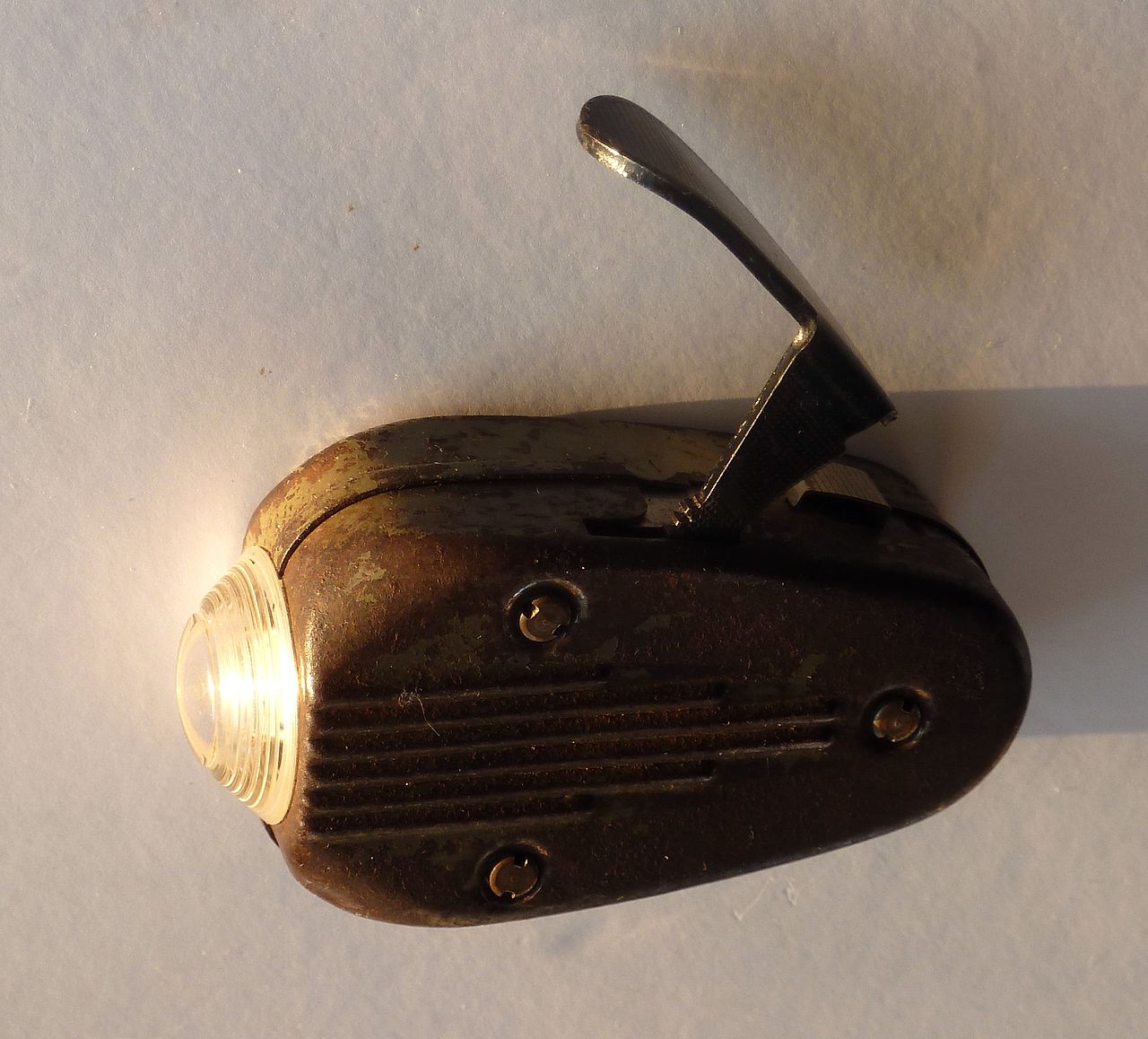
11. The dynamo-powered torch
Power was always a problem during WWII and in 1943 in occupied Netherlands the Philips company built a dynamo-powered flashlight for the troops. Powered by a handle on top, light was generated by squeezing the handle on top. The unit had no battery to charge, so power was only generated while the handle was being rapidly depressed. The torchs were nicknamed the knijpkat (roughly translated as squeezed cat) due to the noise that the dynamo made.
Although previous examples of dynamo-powered torches exist, Philips managed to mass produce them and popularise them: the torches were still on sale in the 50s! They were also built to last: we have one and, more than 70 years later, it still works using the original components and bulbs. Still available today, most torches use a hand crank that charges an internal battery, giving more use for less effort.
10. The Jerrycan
Called the Wehrmachtskanister by the Germans, the Jerrycan is a robust container designed for carrying fuel around. It was invented at the bequest of Hitler to provide a way of transporting fuel by hand. The clever design was reverse engineered by the Allies and put into service to replace their existing canisters, which were easy to puncture.
The Jerrycan is clever for several reasons. First, it has three handles, which lets a can be carried by one person or two people easily, plus passed along a human chain like a bucket full of water for putting out a fire. When empty, the three handles means two cans can be placed side-by-side and one person can carry two Jerrycans in each hand.
The cross design on the side helps strengthen the can, while allowing the contents to expand. There was also an air pocket under the handles. A cam lever release mechanism and short spout with an air-pipe to the air pocket allows smooth and accurate pouring on the contents.

^The humble Jerrycan, a clever design that hasn’t been surpassed in decades of use
9. Pressurised cabins
Flying at high altitude puts occupants of an aircraft at risk of hypoxia (poor oxygen levels in the blood), altitude sickness, decompression sickness and barotrauma (cause by pressure differences). Despite these risks, bombers at the start of WWII were only equipped with oxygen masks, which restricted movement and were prone to failure.
Until the B-29 Superfortress was introduced in 1944, only experimental aircraft had been produced with pressurized cabins. For this plane, the Americans created the first cabin pressure system, with the nose and cockpit sections linked to the aft via a long tunnel, all pressurised. However, the bomb bays remained unpressurised. Even so, this advancement meant the crew could move around in comparative comfort. After the war, the benefits of pressurised cabins were rolled out to passenger planes, allowing us all to fly at high altitudes in relative comfort.

^ The American B-29 Superfortress was a pioneering aircraft with its pressurised cabin
8. Radio navigation and landing
When the war started the aeroplane was relatively new as an instrument of war. How to wield it effectively meant a steep learning curve and some of the greatest inventions that affect how we fly around the world today. Much emphasis, in the UK, was placed on Bomber Command, particularly because in the early part of the war it was the only part of the British armed forces capable of striking back at Germany. It gave the nation hope at a time when there was little. For this, there was a high price to pay and the chances of a bomber command serviceman surviving the war was less than that of an infantryman in WWI. Of the 125,000 British aircrew who served, a staggering 55,573 were killed in action.
One of the most pressing problems was getting planes to and from the target safely, while increasing accuracy. At the start of the war there were no navigation systems and many bomber crews were wildly off target, completely missing the areas that they were supposed to be attacking. This was made even harder by Bomber Command’s decision to fly night time sorties only, under the thought that it was safer than flying daytime raids.

^ The navigator’s section contained all of the equipment necessary for direction finding
In order to help the crews, several navigation systems were created. For accurate blind bombing, the systems Oboe and Gee-H (radio-based systems) were used, although these could only be used by a very number of planes at once. This limited them to being used by the pathfinder force, which used dedicated planes to drop targeting flares in order to improve accuracy for the rest of the bombers.
For everyone else, GEE came into play. GEE was a radio navigation system invented by Robert Dippy, designed to be used by multiple planes. The system worked using three broadcast base stations, sending out transmissions at regular intervals. A master station sent out a single pulse, then the first slave sent out a single pulse one millisecond later, followed 1ms later by the master sending out a double pulse, and finally the second slave sent out a single pulse 1ms later. The entire system repeated every 4ms.
Receiving equipment on board the plane displayed the pulses from the three stations as blips on an oscilloscope. As the time between the pulses was strictly regimented, the display equipment would give the difference in time between the reception of each pulse, and thus the distance from each station. Hyperbolae charts helped the navigator plot the plane’s position. Each hyperbolic line showed a constant time difference for the master and slave stations. Using this, the navigator could look for the intersection of the two hyberbolae representing the slave stations to work out the position.

^ Charts helped the navigator plot the distance from the broadcast stations and thus work out the aircraft’s position
With a range of around 400 miles (accuracy was within a mile at long range over Germany), the system wasn’t accurate enough to be used for blind bombing, but it was enough to set the bomber stream in the right direction and get the planes into enemy territory, where they’d be able to find the targeting flares dropped by the pathfinders.
Part of the beauty of the system was that it didn’t require the bombers to carry any broadcast equipment – unlike Oboe and Gee-H – which meant that the Germans couldn’t detect the bombers using detection equipment. Nor could the Germans use the signals to work out where the attack was going to come.

^ The Gee navigation system helped bombers find their way accurately to the target location
After the war Dippy moved to the US, where he worked on the successor system, LORAN (LOng RAnge Navigation), which had a range of 1,200 miles. This radio based navigation system was used around the world in conjunction with VOR beacon-based navigation and has only recently been phased out due the popularity and increased accuracy of GPS. However, there are campaigns to get funding back into the LORAN system, so that it can be used as a backup should GPS fail. From Bomber Command’s desire to strike back at Germany came the very first radio navigation system and the start of modern accurate direction finding.
Landing
Getting up was one thing, but landing successfully, particularly in the dark was just as dangerous for bomber crews. It was with this in mind that several systems were developed by the Allies to help the incoming bombers set-down safely. Key to this was the Rebecca transponder unit mounted on the aircraft. In itself it acted as a system to tell friend from foe, and similar systems are used on modern planes to identify them. Rebecca could also be used with the Eureka ground-based transmitter.
When the bombers neared home, the Rebecca unit sent out a transmission, which triggered Eureka to reply. The returned pulses were measured on the left and right aerials. By measuring the signal amplitude on both, it was possible to tell which direction Eureka and the airfield lay. Meanwhile, the delay between the broadcast and reply gave range, accurate to within two miles. From this technology modern beacon-based navigation systems were invented, many of which are still in operation, although GPS is taking over. Once the planes knew where to land, the job wasn’t done and the British invented the Blind Approach Beacon System (BABS) to help aircraft land safely.

^ Landing aircraft was made safer and easier by the Blind Approach Beacon System CROWN COPYRIGHT, RAF MUSEUM: Crown copyright material is reproduced with the permission of the controller of Her Majesty’s Stationery Office
It was the first radar landing system to be created. The system uses a transponder placed in a Hillman van at the end of the runway. This was interrogated by the Rebecca unit mounted in the aircraft. In response the BABS sent a transmission of dots on one side of the runway and dashes on the other side. The strength of the reception of both signals could be used inside the aircraft to tell its relative position, and help the pilot align the aircraft safely.
Today, the Instrument Landing System (ILS) uses a similar system, presenting the pilot with instructions on whether to fly left, right or even up or down. This technology is essential to helping thousands of planes across the world land in poor conditions, every day.
7. Penicillin
Discovered by Alexander Fleming in 1928, it wasn’t until 1939 that Howard Florey and a team of researchers showed the potential of penicillin; and it was during the war that the antibiotic gained its popularity. In 1943 the US War Production Board came up with a plan for the mass distribution of penicillin to Allied troops fighting in Europe. By 1944, the US had produced 2.3 million doses and the medicine is credited with saving an estimated 12 to 15 per cent of casualties.

^Widespread use of penicillin during the war probably saved millions of lives, and countless more since
6. Synthetic rubber and oil
A shortage of oil meant that the Germans desperately needed an alternative and came up with a blend of adipic acid ester with poly(ethylene) oil. It helped keep the Luftwaffe in the air during the duration of the war. The Americans also developed their own synthetic oil and started using it in the airforce once it was discovered that synthetic oils made the planes easier to start in winter and reduced soot deposits in oil radiators.
In addition, with the Axis powers in control of most of the world’s supply of natural rubber, there was a desperate need for the Allies to improve synthetic rubber production. In 1940, Waldo Semon developed Ameripol, which was cheaper to produce and easily met the Allied need for rubber.
5. Radar
In 1886 Heinrich Hertz showed that radio waves could be reflected by solid objects, setting in motion the technological advancements that would become Radar and even leading to microwave ovens. This work was to be heavily developed and improved upon during the war, particularly by the British who had need of the technology to detect incoming bombers during the Battle of Britain and scramble a fighter response.
With the prospect of war looming over Britain, investigations were made into the potential weapons that the Germans might deploy. One worry was a ‘death ray’ was being prepped, following a claim by Nikola Tesla. In 1935 Robert Watson Watt, an expert in radio, was contacted to find out if radio waves could be used in this ‘death ray’. Watt, after talking to his assistant Arnold F. ‘Skip’ Wilkins wrote back that it was unlikely, but added a comment that said, “Attention is being turned to the still difficult, but less unpromising, problem of radio detection and numerical considerations on the method of detection by reflected radio waves will be submitted when required.”
Several weeks Wilkins submitted a paper called The Detection of Aircraft by Radio Methods, which outlined how a transmitter and receiver could be built to bounce radio waves off an airplane for detection. Proof was needed. On February 26 1935, Wilkins showed a demonstration with a receiver set in a field in Northamptonshire. A Handley Page Heyford bomber flew on a path between the receiver and the BBC shortwave transmitter. The aircraft reflected the signal and the Air Ministry was convinced that this new technology could work and development of the new technology, called Range and Direction Finding (RDF), began. The name was partially picked, because the acronym was the same as for Radio Direction Finding, a well-known existing technology. It was the US that coined the term Radar, which stands for Radio Detection and Ranging.

^ Chain Home was one of the first deployments of Radar, helping the British to scramble fighter response to incoming German attacks CREDIT: Stuart Axe
One of the first deployments of Radar was in the Chain Home system, designed to act as an early warning of attacks. It was primitive and looked nothing like other radar systems. It had no rotating dishes and the transmitters were fixed wire strung between 110m-high towers. Receivers were mounted on 75m tall wooden poles. With these towers erected along Britain’s coast from Portsmouth to Orkney Islands, the coast was covered. While there were some problems, the system gave an early warning of German attacks and allowed the RAF to accurately scramble fighter responses.
Of course, the British weren’t the only ones developing Radar and the Germans had their own version. One of the main uses for the German Freya Radar was in the Kammhuber Line, which ran from Denmark to the middle of France. This line of radar detection would pick up any Allied bombing attacks, allowing the Germans to scramble their night fighters.
Particularly scary for Allied bomber pilots were the master searchlights, which were Radar controlled. These would lock onto a bomber, then the other manually controlled lights targeted onto the plane, lighting it up for anti-aircraft batteries and night fighters to attack. In turn this led to the British coming up with counter-measures. One of the most simple was called Window. Using this system the rear gunner would throw out strips of foil, which would appear on the German Radar as enemy planes, distracting them from the real attack and helping to confuse the master search lights. It was first used to devastating effect on the attack on Hamburg, where a firestorm practically wiped out the city.

^The Germans had their own Radar, including this portable Wuzrburg model
Improved accuracy
Where the Allies really won out was through the development of the cavity magnetron. This microwave transmitter (now used in microwave ovens to heat food), allowed for smaller, more accurate radar systems to be created that could detect much smaller objects. The modern cavity magnetron was created by John Randall and Harry Boot in 1940 at the University of Birmingham. With Britain not having the money to mass-produce and develop the idea, a working sample was sent to the US where the Bell Telephone Laboratories created a version that could be manufactured.

^ Not only did the cavity magnetron allow the allies to install radar on planes, it also led to the microwave oven and a million TV dinners
With this technology, the Allies had a massive advantage over the Axis. One of the key advantages was that the Radar could now be made small enough to install on planes. H2S was one of the main systems, allowing bombers to map the ground beneath them, giving them a huge advantage in blind bombing and improved accuracy. It also led to problems, such as German night fighters being equipped to detect H2S signals and so locate the bombers. Maritime patrol aircraft used the high resolution radars to detect objects as small as a submarine’s periscope, allowing them to destroy German U-Boats that were previously undetectable.
Auto-tracking anti-aircraft, or ‘Gun-laying’, guns were also created and placed in the path of V1 flying rocket. Their accuracy and resolution meant that many of the bombs were destroyed before ever hitting their targets. Although the cavity magnetron only really lives on within microwave ovens, it kick-started the era of modern radar. Radar is now used in thousands of applications from military to civilian. It’s used in aviation to warn pilots of obstacles and to give accurate height readings, and in maritime use to help ships avoid collisions with other ships. It’s even used, less popularly, by the Police to detect the speed of cars.
4. The V-2
Hitler’s second Vergeltungswaffe, or Vengeance Weapon, may have killed over 2,500 people (and 20,000 more died in the process of making it) but it was a key step forward in putting a flag on the moon, as well as developing GPS, Google Earth and satellite communications. While the V-1 was a relatively crude guided missile, the V-2 was an astonishingly advanced weapon. The world’s first intercontinental ballistic missile had a range of 200-225 miles, reached an altitude of up to 60 miles and could strike London just three minutes after its launch in Holland.

^ The V-1 was a relatively crude guided missile that was often destroyed before causing any damage
The V-2 is the ancestor of all modern rockets, and is related to the vehicles that launched Sputnik and put the first American in space – the Soviet R-7 and US Mercury-Redstone. This was no accident; after the war both the US and Russia appropriated V-2 missiles and related equipment, and both powers hired former V-2 engineers to help with their missile programs. Although rockets had been used in warfare for hundreds of years, traditional solid fuel didn’t have the energy density needed to propel a vehicle for hundreds of miles, and made it impossible to throttle the thrust. Rockets were also far too inaccurate to hit a target on another landmass. The V2 counteracted this with two major innovations: liquid propellant and inertial navigation.
Fuelling the rocket
Even before war broke out there was keen interest in using liquid fuels to launch rockets in both Europe and the United States. An American, Robert H. Goddard, launched the first liquid-fuelled rocket in March 1926, and in Germany in 1929 Austro-Hungarian scientist Hermann Oberth successfully fired a liquid-fuelled rocket engine.
Oberth’s assistant at the test firing was Walther von Braun, who went on to head up the German army’s rocket research. By December 1934, at the Kummersdorf proving grounds near Berlin, von Braun had his first successful test firing – a small, 1.6-metre long ‘A-2’ rocket, which burnt a mixture of alcohol and liquid oxygen to reach a height of 2.2 miles. Two years later the research centre was moved to the island of Peenemünde, on Germany’s coast to the south of Sweden, where testing began on A-3 and A-5 rockets – test beds for components to be used on the proposed A-4 model, which would become the V-2 ballistic missile.

^ This U.S Army cutaway of the V-2 shows the large oxygen and alcohol tanks, as well as the turbine which forces the mix into the combustion chamber – click to enlarge
One of the main problems faced by the scientists was generating enough thrust to lift a rocket as large and heavy as the V-2 into space. The A-2 rocket generated 300 kilograms of thrust, but the V-2 needed 25,000. To get the required thrust a way was needed to a sufficient flow of fuel to the combustion chamber to maintain the speed of the reaction and so generate enough power. The V-2’s final engine used twin gas turbine-powered pumps to push vast amounts of an ethanol/water solution plus liquid oxygen into a combustion chamber, where they mixed and ignited to produce a huge amount of thrust. This alcohol/oxygen mix continued to be used well after the war – the US Army’s PGM-11 Redstone rocket used the same fuel configuration and stayed in use until 1964, while a retired Redstone rocket launched Australia’s first satellite – WRESAT – in 1967.
Even though von Braun’s military backers ensured liquid-engined rockets were developed far faster and to a more advanced degree than Robert Goddard managed in the States, von Braun was in no doubt as to the debt he owed the American. While at NASA in the 60s he stated that Goddard’s early rockets “blazed the trail and incorporated many features used in our most modern rockets and space vehicles”.
Control systems
Even with von Braun and his team managing to get the V-2 to generate enough thrust to escape the atmosphere, they also needed a way to keep the missile on course during the thrust phase, so that when the engine was cut off the missile was at the correct angle and speed to hit its target. Once the engine cut off, after around 60 seconds of thrust and 50 miles above the Earth, it behaved like an artillery shell – falling in a curve to its target at three times the speed of sound.
Most V-2s guided themselves to their target, relying on internal instruments to determine the rocket’s current flight path and speed – unlike modern rockets, the V-2 sent little information back to the ground, so once it was launched it was largely on its own. To maintain a flight path, the V-2 needed to measure pitch, yaw and roll. It also needed to know when it was accelerating at the correct rate, at which point it would shut off the engine.

^ An early internal guidance system used in the A-3 development rocket. It proved too unstable leading to every A-3 launch crashing after takeoff
To maintain the right direction, the V-2 used a navigation system with two gyroscopes – one mounted horizontally and one vertically. Mounted on gimbals, the gyroscopes would stay in their original orientation, no matter how the rocket moved. As the gyroscopes maintained an absolute position, the system was able to measure the rocket’s movement around them, and so determine how much it had moved. To correct the rocket’s course the gyroscopes controlled a combination of air vanes mounted on the rocket’s fins, and, because air vanes are no good once you run out of atmosphere, vanes were also mounted on the edge of the rocket booster to control the direction of the rocket’s exhaust. This guidance system was known as the LEV-3.
Two methods were used to determine when to cut off the rocket motor. The first successful launch of the V-2 rocket, in October 1942, used a Doppler radio beam to measure acceleration from the ground, but there were worries that the Allies could jam or interfere with the beam and sabotage the launch. For this reason, most V-2s used an accelerometer to determine when the engine should be shut off – by which point the V-2 would be travelling at 1,341 metres per second.
The guidance was reasonably accurate, and certainly good enough to hit a target the size of London. That the USA’s Mercury-Redstone rockets, which put the first chimpanzee and the first American, Alan Shepard, into space, used the same LEV-3 guidance system as the V2 is testament to its accuracy. This system is also the basis of today’s inertial navigation systems, which keep everything from aircraft to submarines to guided missiles on track.
The reason more Londoners weren’t killed by Hitler’s ultimate weapon lies partly in a British disinformation campaign; double agents reported back to Germany that rockets were overshooting London by 10-20 miles. Once the rockets were recalibrated accordingly, many landed in the relatively sparse areas South-East of London – the last V2 fired landed in Orpington, Kent on 27th March 1945.
Without Germany’s rapid development of the V2 rocket, the rush to develop an intercontinental ballistic missile in the post-war years may never have been so intense. The leap forward that the pressures of war put upon the Axis and Allies development programmes put us decades ahead of where we would otherwise be when it comes to everyday technologies such as satellite communications.
3. Jet engines
Although Sir Frank Whittle had his first jet engine working in 1937, the British government wasn’t particularly interested in it and work progressed slowly. It was the Germans who really pushed the technology, with the Messerschmitt Me 262 being the first jet-powered fighter aircraft. Compared to the propeller-powered fighters of the day, the Me 262 was a far superior plane and considerably faster. It was introduced in 1944, and its pilots claimed a 5:1 ratio of allied planes shot down to Me 262s lost.
The Germans also produced the Arado Ar 234, which was the first jet-powered bomber and the last Nazi plane to fly over England in April 1945. Although it saw little service, its speed made it practically impossible to intercept. Jet engine research continued, and the Heinkel He 162 single-engined jet fighter was produced towards to the end of the war. Fortunately for the Allies, fuel shortages dramatically reduced the impact of the Germany’s jet aircraft.

^ The Gloster Meteor was the only British jet plane to see action during the war CROWN COPYRIGHT, RAF MUSEUM: Crown copyright material is reproduced with the permission of the controller of Her Majesty’s Stationery Office
Meanwhile the British worked on its own jet fighter, the Gloster Meteor. Starting operations in July 1944, it was primarily used to shoot down V-1 flying bombs. Once that threat was over, the Meteor was banned from flying over Germany for fear one would be shot down and salvaged by the Germans. By the end of the war, the propeller planes that fought in it were no match for the jet engine models invented during it. The age of the jet engine, which continues today, had begun.
2. Nuclear power
The potential power stored within the Atom had been known for a long time, but it was during WWII that the race to harness its power really began. The US got there first with the Manhattan Project, which developed the first Atom bomb in history. On August 6th 1945 the bomb was dropped on Hiroshima, then on August 9th 1945 a second bomb was dropped on Nagasaki. It’s estimated that between 150,000 and 244,000 people were killed as a direct result.
There’s been a lot of controversy surrounding these events and the proliferation of nuclear weapons since. However, without this discovery there would be no nuclear power, which has largely remained a safe and, arguably, comparatively clean way of generating electricity.

^ The mushroom cloud over Nagaskai following the dropping of the second atomic bomb
1. The first computer – Colossus
With the Germans encrypting practically every message, Bletchley Park was put into operation to decode them and give the Allies a massive advantage. In the process, the incredible team that worked there, created the world’s first computer.
The main focus of Bletchley Park was breaking the code generated by the German Enigma machine; which involved creating another mechanical machine, known as the Bombe. However, the cryptologists were also tasked with breaking the far-harder Lorenz cipher, whose traffic was known as Tunny. This was created by Lorenz machines, which were far larger, and therefore not portable, but much more complex than Enigma. As this traffic was used by the German High Command, the messages encrypted were incredibly important. Lorenz machines were closer to modern encryption than the substitution-cypher-based Enigma.

^ Bletchley Park broke the German encryption and ended up being home of the first computer
They were teleprinters that output messages not as text, but with each character composed in five-bit baudot code. To encrypt the data, the Lorenz machine generated five pseudorandom bits, which were eXclusive ORed (XORed) with the plaintext. This operation looks at pairs of bits, and outputs a 1 if only one of the characters is a 1, otherwise the output is 0. So 1 XOR 0 = 1, but 1 XOR 1 = 0. Each character output in the Lorenz machine would be XORed with the pseudorandom bits, such as: 10010 XOR 11001 = 01011. The important thing about XOR operations is that XORing the output with the pseudorandom bits reverses the encryption, so, 01011 XOR 11001 = 10010. The same principles apply in modern cryptology, and the use of binary is exactly how modern computers work.
The Lorenz machine generated its pseudorandom bits through a set of ten pinwheels, where the encryption key was determined by the starting position of the wheels. There were five pinwheels which stepped regularly (chi) and five which stepped irregularly (psi). The irregular stepping of the psi wheels was controlled by two extra wheels, called the motor wheels. The Lorenz machine actually double-encrypted the data, first generating a five-bit pseudorandom code for the chi wheels, then generating a second five-bit pseudorandom code for the psi wheels. However, the order in which these are applied, both in encrypting and decrypting, are not important.
Statistical attack and Colossus
W. T. (Bill) Tutte working at Bletchley Park discovered how to break Lorenz using statistical methods to break both parts of the key: the pin settings for the wheels (known as wheel breaking) and the wheel setting (the starting positions of each wheels). The wheel breaking was often done by hand, using Tutte’s rectangling method, which involved writing down the bits of message in a rectangle, then statistically analysing the results for patterns that gave away the pin positioning.
Once this had been worked out, the starting positions of the wheels could be worked out. Tutte worked out was that the psi wheels were a weak point in the encryption, as they moved irregularly. Therefore, the output from these wheels was the same for many characters. As such, the important thing was to start with the regularly stepping chi wheels.

^ Colossus was the first computer ever built and currently has a working replica at Bletchley Park
Tutte also worked out that you could work on pin wheels in pairs. So, while there were 22 million possible wheel start positions, there were just 1,271 possible starting combinations for the first chi wheels. Due to the way the system worked, guessing the first two chi wheels would remove the first two encrypted bits throughout the entire message. It was then possible using the partially decrypted code to statistically analyse the result looking for patterns in the language, such as where a character is repeated twice in a row, such as in the English word, look, which has ‘o’ repeated twice. Similar rules apply for German, too.
From there, assuming the first two wheels are set correctly, there were only 598 combinations of starting positions for the last two wheels. Once they were set, this left just 29 positions for the third wheel, meaning that only 1,898 starting combinations were needed to break the chi wheels. Once this was complete breaking the Psi wheels was considerably easier.
The only problem now was to automate the problem, which is where Max Newman came in, as he believed it was possible to build a machine to automatically perform some of the calculations. The initial machines, named Heath Robinson, proved unreliable but were a good starting point for Tommy Flowers, who decided you can build an electronic machine for reading cipher text, performing the necessary calculations and outputting the results on a printer. In other words, the first computer – Colossus.

^ Traffic of the Lorenz machine was harder to decode than that of the Enigma machines
Initially its job was to optically read in ciphertext characters, and count repeated characters on them for all of the combinations of the chi wheels, based on its programmed wheel settings, outputting the results to a printer. The lines with the highest counts above a set statistical value where the most likely chi wheel settings. These were passed onto to a team that would break the easier psi values by hand and check the chi settings manually, decoding messages on a replica Tunny machine.
Operating at 5,000 characters per second, Colossus was capable of working out the chi settings in less than 30 minutes. However, it was also discovered that Colossus could be programmed for wheel breaking, massively reducing the time that this took. This is a key development, as Colossus could be programmed, evolving the job that it could do to match the situation.
Sadly, after the war Colossus was broken down and kept a secret, so details of how it worked was not widely known. As such, it had little impact on the development of computers and modern computers are evolved from subsequent projects. However, the idea of Colossus helped everything. Once this computer had been built, it was known that a high-speed electronic computer could be made reliably. It was this information that helped push the development of subsequent computers, so the importance of Colossus on the modern world should not be overlooked.


